04.11.14
Transport for London plans Tramlink extension in Croydon
Transport for London (TfL) is considering a new tram loop near East Croydon station that would support the redevelopment of the old Whitgift Centre site.
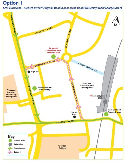
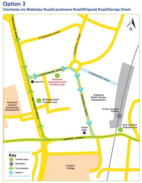
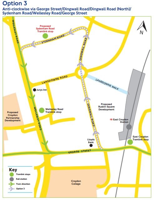
London Tramlink currently operates in a one-way loop along George Street, Church Street, Tamworth Road and Wellesley Road. But TfL is considering three possible loop extension options that could be constructed in the New Town part of Croydon.
It was stated that building a new loop would help TfL to continue to maintain a reliable service and provide more capacity on the London Tramlink network.
Now a consultation is seeking the views of residents and stakeholders of both the Dingwall Road loop extension in principle, as well as which of the three route options is preferred.
Alex Williams, TfL’s director of Borough Planning, said: “Croydon has very ambitious town centre redevelopment plans, which will need improved transport infrastructure to make sure people can get around the area easily.
“We want to hear local people’s views on these proposals which have been developed closely with both Croydon Council and the Mayor’s Office to help support this growth.”
Croydon is undergoing one of the largest town centre regeneration projects in London with the redevelopment being led by the Croydon Partnership.
The project is expected to create over 5,000 permanent local job opportunities and deliver between 400 and 600 new homes, with the number of passengers using Tramlink services in the area expected to double by 2031. Subject to funding, the long-term aspiration is to increase the tram capacity in Croydon by 36%, enabling an extra 1,600 passengers to travel an hour in each direction.
TfL added that all the options for the extension have different benefits and outcomes.
Option 1 – Anticlockwise

A lower impact to the existing highway and pedestrians than Options 2 and 3. A lower impact than Option 3 to:
- Utilities
- Land requirements
- The environment
- Taxi and car usage
It is the preferred location of the tram stop to serve the Croydon Partnership Development.
Option 2 - Clockwise

Option 2 has a more complex junction on Wellesley Road than Option 1, with greater impact to the existing highway and pedestrians; particularly with the proposed pedestrian crossing.
Running the tram/bus lane contraflow on Wellesley Road along with other road users is more challenging than the anticlockwise scheme proposed in Option 1.
A lower impact than Option 3 to:
- Utilities
- Land requirements
- The environment
It is the preferred location of the tram stop to serve the Croydon Partnership Development for westbound passengers from Wimbledon and Therapia Lane, who will no longer use Wellesley Road stop.
Option 3

It would connect Tramlink to new passengers on Dingwall Road (North) and Sydenham Road who currently have longer to walk if they want to catch a tram. It is the longest of the routes and thus has the greatest impact on:
- Third parties and stakeholders
- Landowners
- The environment
This route would have the greatest impact to the existing highway arrangement and junction signals. The proposed stop location is not ideal for serving the new retail development. The existing bus routes would remain during the operational phase of the loop.
The public consultation will run until 14 December 2014. Further information about the consultation and the questionnaire can be found at www.tfl.gov.uk/dingwall-road-loop.
(Images: c. TfL)
Tell us what you think – have your say below or email [email protected]